We had
a long run from Gulf Shores Alabama across Mobile Bay and into the GWII which
is in the Mississippi sound between land and the barrier island. The wind was
brisk, but we couldn’t sail as the channel is narrow and there are “spoil areas”
or Obstn. Fish haven, Subm. Piling, marked out in nearly every blank spot on
the charts. The one I particularly liked was marked EXPLOSIVES ANCHORAGE
AREA. The few places we could duck into
once we crossed the bay, were for boats with less than 4’ draft. We finally opted for the least objectionable
anchor site off a wreck about 1 mile out from Petit Bois Island. We were hot
and tired and the only saving grace was a strong wind coming through the open
hatches.
Tom
woke me about 5 am to close those hatches because a large angry red splotch on
the Sirius radar gave us a good chance of getting dumped on. The storm petered
out once it hit water nevertheless we pulled up anchor by 6:30 and were on our
way again. We decided to run to Gulf Port Mississippi, the city marina looked
inviting. Active Captain gives them a #1
rating … again I am puzzled. We called ahead and they were very busy … get back
to us. Never did. Called again, they put
us in a short slip after Tom repeated 3 times we are a 40’ sail boat, now she
is puzzled, call back. We wanted to fuel up and called 4 times -someone was to
be there. NOPE we circled around for five minutes. There is no WI-FI, no
welcome package with maps of area; they leave you on your own. By the way not
one boat has come in after us and we did not see one boat in the channel coming
in.
I
realize my expectations have changed considerable since we left Michigan almost
a year ago. I look back at entries I made then, complaining about 40 degree
weather for one, while Tom and I sweat buckets trying to get tied to our
dock. We never complained about fixed or
floating now we want Fixed. Now I ask if there is air conditioning in the
Showers, also if the doors lock. Getting picky in my old age I guess.
We are
here in Gulf Port for the weekend. Renting a car, going to try and find some
maps of the GWII through New Orleans… So far it looks like one crazy mess.
Any one
reading this if you have a clue, let us know.
Roasting
in Mississippi
 |
| Shrimp boat passing us in the Ditch |
 |
| Entering Mobil Bay
Mobile Bay is an inlet of the Gulf of Mexico,
lying within the state of Alabama in the United States.
Its mouth is formed by the Fort Morgan Peninsula
on the eastern side and Dauphin Island,
a barrier island on the western side. The Mobile River and Tensaw River empty into the northern end of the
bay, making it an estuary. Several smaller
rivers also empty into the bay: Dog River, Deer River, and Fowl River on the western side of the bay, and Fish River on the eastern side. Mobile Bay is the
fourth largest estuary in the United States with a discharge of 62,000 cubic
feet (1,800 m3) of water per second.[1]
|
 |
| Pelicans are cool but they do make it difficult to read the markers some time |
 |
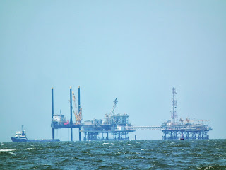
| derelict platform |
 |
| Two Toot pass of tug |
 |
Offshore oil and
gas in the US Gulf of Mexico is a major source of oil and natural gas in the United States. The western and central Gulf of Mexico, which includes
offshore Texas, Louisiana, Mississippi, and Alabama, is one of the major
petroleum-producing areas of the United States. In 2007, federal leases in the
western and central Gulf of Mexico produced 25% of the nation's oil and 14% of
the nation's natural gas.[1]
|
 |
Major fields include Eugene Island block 330 oil field, Atlantis Oil Field, and the Tiber oilfield (discovered 2009). Notable oil
platforms include Baldpate, Bullwinkle, Mad Dog, Magnolia, Mars, Petronius, and Thunder Horse. Notable individual wells
include Jack 2 and Knotty Head.
|
 |
| Petit Bois Island National Wildlife Refuge |
 |
| all we needed was taps |

 |
| Pascagoula across from our anchorage |
 |
| sun rise, storm clouds, humid air, but seas not as choppy |
 |
| Tug approaching us and kind-of - meandered a bit so I could not put up the sun sheet until it was passing us |

 |
| Gross law of Tonnage said to let this ship proceed us up the channel.. |
 |
| It was docked and unloading when we made the turn into our marina. |

No comments:
Post a Comment